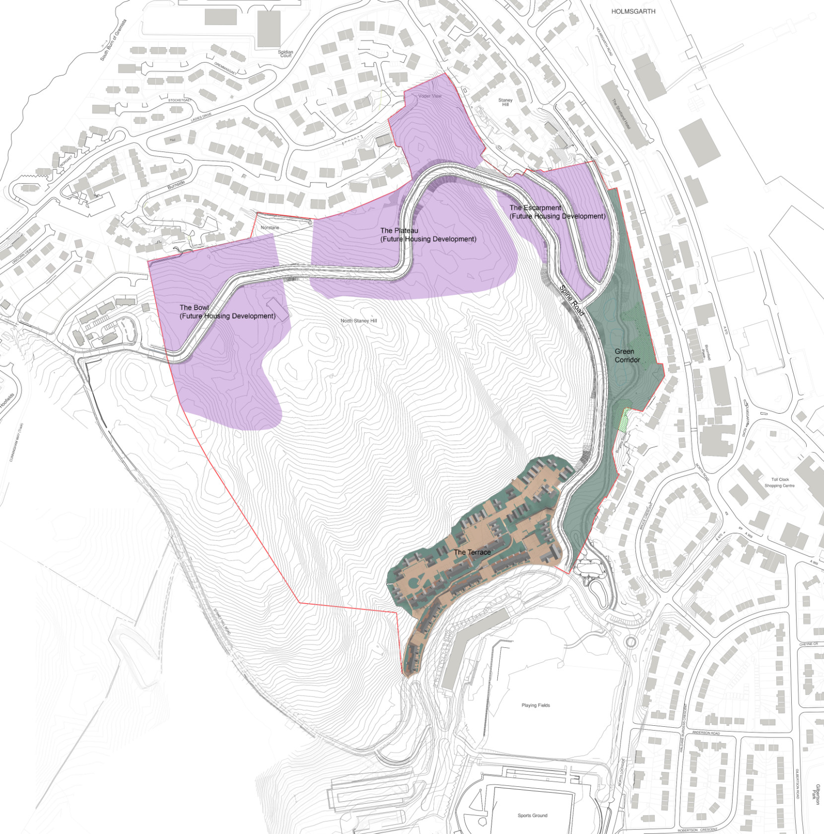
North Staneyhill
North Staneyhill – 124 new Houses/ Flats and Infrastructure
Including Spine Road and Green Corridor Amenity Space
The Planning Application for this project has now been submitted. Details can be found at;
The public consultation for this project closed on 5th June 2020. Many thanks to everyone who commented and submitted questions on the proposals.
Background
Hjaltland Housing Association bought the site at North Staneyhill in 2015 for the purpose of providing new affordable homes in order to meet the high level of housing demand in Lerwick. The Association completed a master planning process for the entire site and following public consultation, the masterplan for North Staneyhill was approved and adopted as supplementary guidance by the Shetland Islands Council Planning Department in March 2018.
The Masterplan
This masterplan sets out the principles for developing the North Staneyhill site including the indicative route for a road through the site and the areas designated for the housing developments and public green space. All the future developments within the masterplan site, including those which are included in this project must be designed within the overall framework and design principles set out in the masterplan documents. These documents can be accessed on the Shetland Islands council website at https://www.shetland.gov.uk/planning/LocalDevelopmentPlan.asp
The Project
This proposed development is for approximately 120 affordable homes and a new office building at The Terrace. It also includes a new road (the Spine Road) which will lead from North Loch Drive to Wista at the North West with branches off to Staneyhill. At the East edge of the site between the new road and the existing housing a public green space is proposed (the Green Corridor). This will provide public amenity space and also be designed with a series of retention basins to deal with the surface water from the new road and housing developments.
For this project we are seeking comment on the design development carried out since the masterplan was approved relating to The Terrace, Green Corridor and Spine Road.
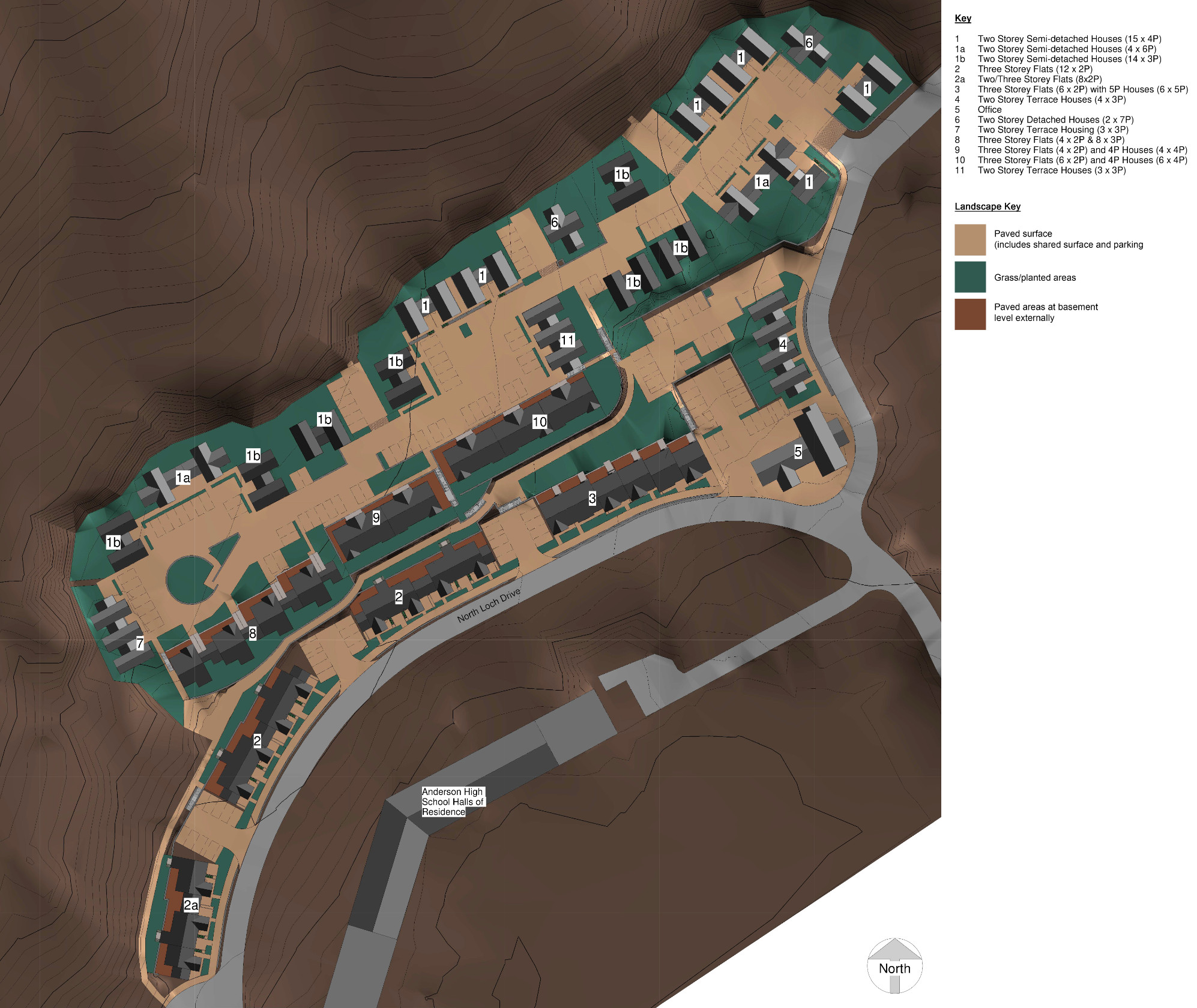
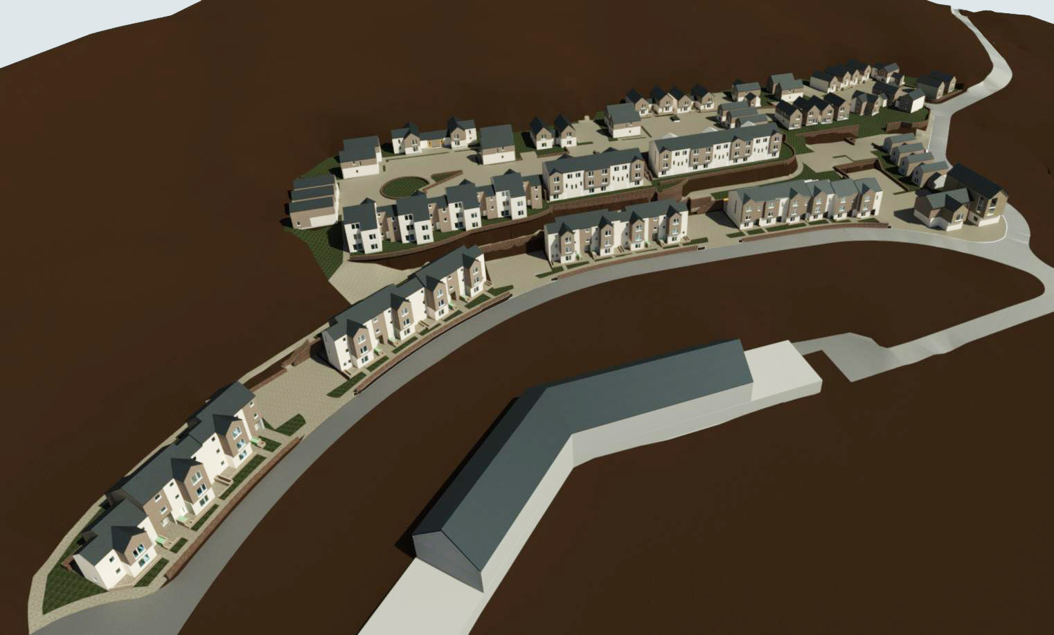
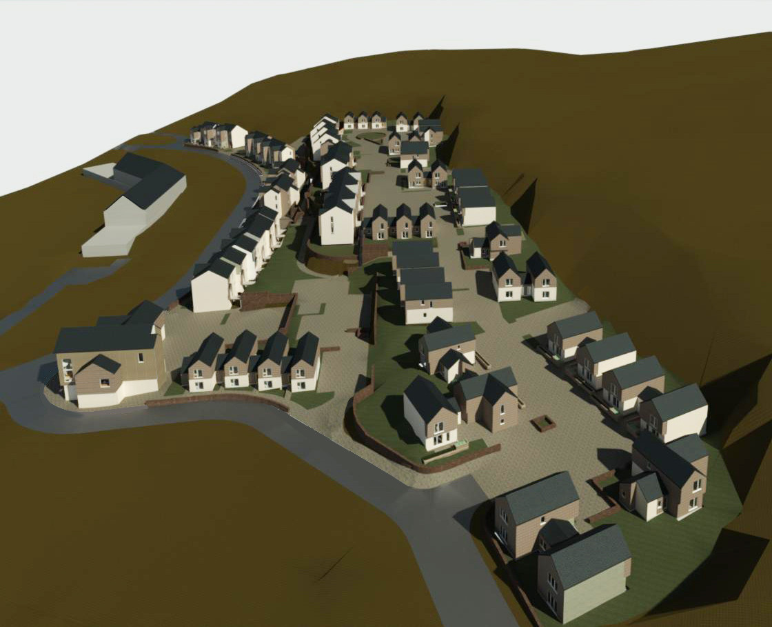
The Terrace
The site for the terrace sits immediately to the North of North Loch Drive, close to the Anderson High School and Hostel as well as the Clickimin Leisure Complex. The site is steeply sloping and to accommodate this the proposal is for some of the housing to be accessed from North Loch Drive and the rest from the new Spine Road at higher level. The new housing proposed at North Loch Drive is to be set back from the existing road with a strip of planting and green space to separate these new homes from the existing footpath and create some privacy for windows at street level.
The proposed office building is located on the corner of North Loch Drive and the new spine road and is intended to be a prominent building in keeping with the principles set out on the masterplan.
The main housing area at the upper level of the terrace has vehicle access off the new spine road. This access leads to a shared surface area which is designed to limit the speed of traffic to less than 20 miles per hour and provide a safe attractive space for pedestrians, cyclists and for children to play. This shared surface has three distinct wider areas, one at the entrance from the Spine Road, one about half way along its length where a square is formed with housing around the perimeter and the final area at the end of the upper road where a curved garden area is planned at the centre of the space. A mixture of raised planted areas and stone walling is proposed to form the edges of the shared surface and to break up the space to reduce straight lengths and keep traffic speeds low. Planters and landscaping to the front of the housing where it meets the shared surface will provide privacy to ground floor windows while maintaining an open feel to the public spaces.
In line with the design coding of the Masterplan the proposal is to use a mixture of larch cladding and render. The intention is to use more colour within the upper terrace area in windows, doors and possibly areas of painted timber cladding to add variety and interest to the space. Stone from the excavation works is intended to be re-used to form the stone walling proposed in the landscaped areas.
THE MAIN SPINE ROAD
The main spine road will be approximately 1km in length from the junction with North Loch Drive to Wista in the North West. It will comprise a two-lane 6m wide carriageway, which is intended to be a bus route, with accompanying 3m wide shared use path (shared cycling and walking route) along its full length on the right hand side (when travelling from North Loch Drive to Wista). The shared use path will be separated from the road by a 1m grass verge. On the left hand side, there will be a 2m wide footway.
The layout of the spine road corridor is intended to minimise earthworks and to provide a number of curves for reducing vehicle speeds. Typically the spine road will involve rock cut embankment on the upper side and landscaped fill embankment on the lower side. Design speed for the road is 20mph.
Main underground services e.g. mains electricity, water, telecoms and foul and surface water drainage will be laid along the main spine road corridor with connection tails left for proposed future housing areas (The Bowl, Plateau and Escarpment). Surface water drainage will include new cut off ditches and landscaping to intercept and divert run-off away from existing and proposed developed areas, and Sustainable Urban Drainage (SUDS) features located within the green corridor for the attenuation and treatment of run-off from new developed areas. LED street lighting will be provided along the main spine road and designed to ensure adequate lighting levels for the road, footway and cycleway throughout.
Proposed Upper and Lower Escarpment roads will extend through from the existing Staneyhill roads and are intended to link back into the Main Spine Road. Footways, underground services and street lighting will also be incorporated into these two additional links.
It is intended that rock excavated from the Terrace housing area will be processed on site to produce fill material for constructing the Main Spine Road therefore reducing the amount of imported quarry material.
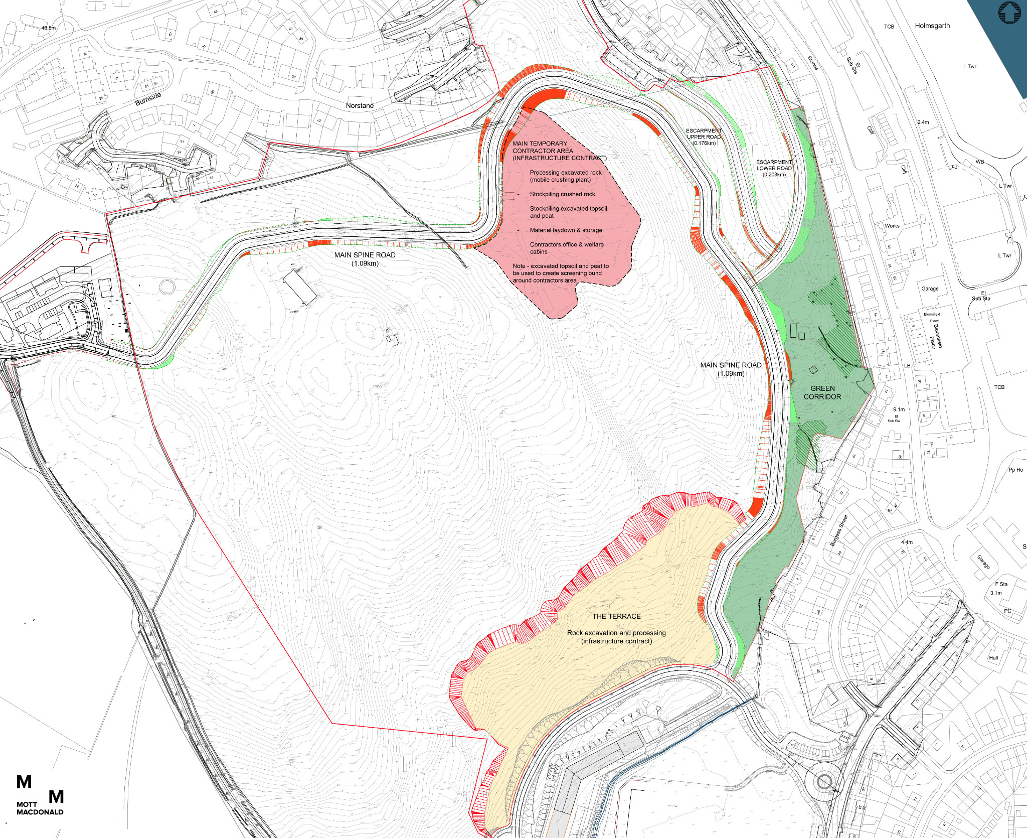
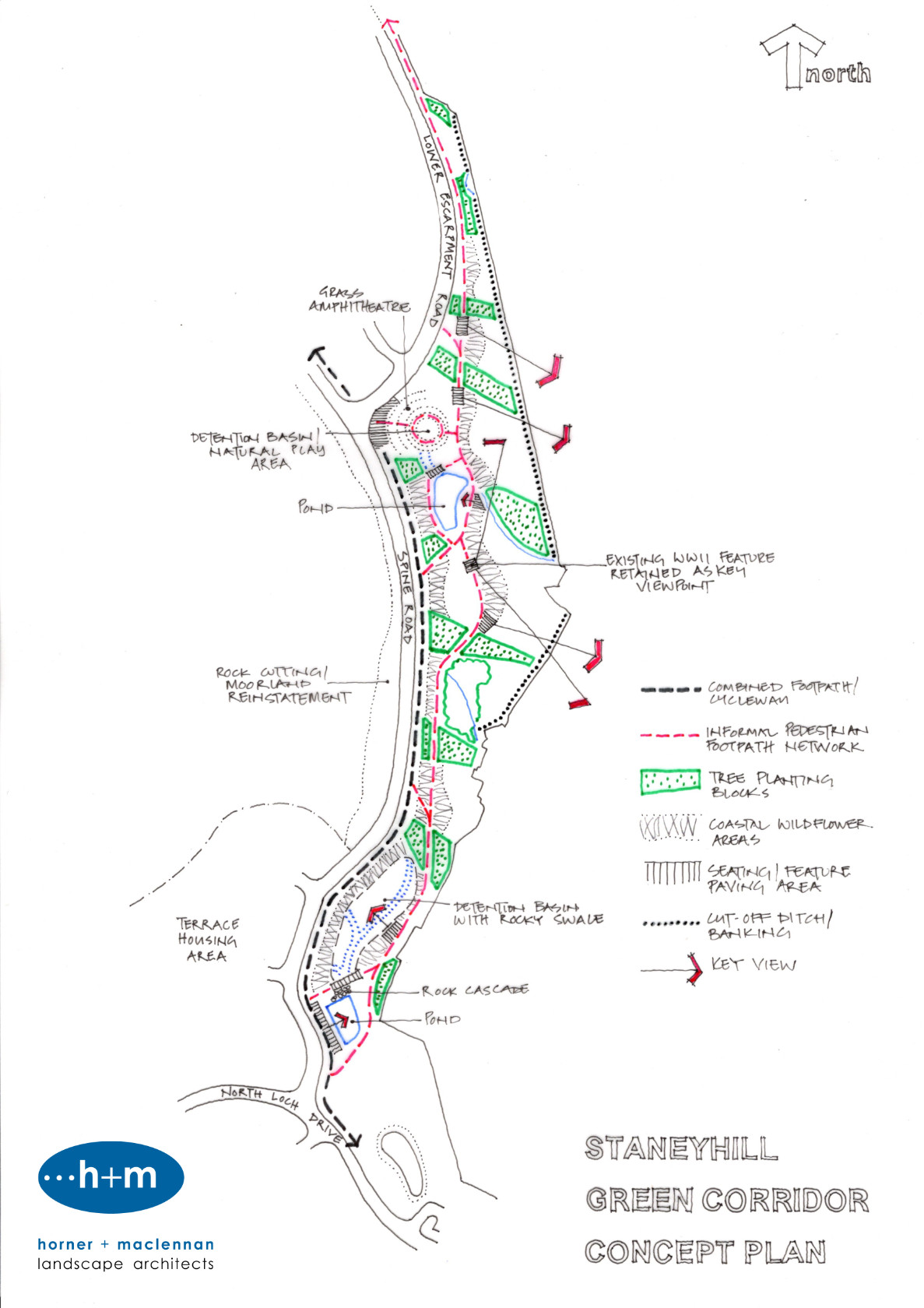
The Green Corridor - Design Approach
CONTEXT
The green corridor forms one of the major parkland spaces of the Staneyhill development, forming a linear wedge of open space along the eastern edge of the site. It incorporates the only area of established trees on the site, which act as the basis to develop a stronger and more distinctive landscape character to this part of the development. The underlying concept for the green corridor is the integration of a range of engineering components to optimise their amenity potential and value. The design approach for the green corridor comprises of a sequence of inter-related and integrated themes which are described below.
SURFACE WATER MANAGEMENT
A key component of the green corridor landscape will be a sequence of ponds, basins and swales primarily aimed at controlling, attenuating and treating surface water runoff from the residential development areas. The underlying design concept is the integration of these engineering features through their design treatment, so that they contribute positively to the character, identity, biodiversity and amenity of the green corridor. These features will celebrate the flow of water through the site, creating a diverse range of water-based elements which can provide interest even during dry periods.
The northern basin is designed as a grass terraced amphitheatre, aligned to provide key views over the town and harbour to the south-east, which will be predominantly dry except during storm events. Its location at the intersection of the spine road and the lower escarpment road creates a key landscape feature to lead people into the green corridor parkland from the north and west. The central base level of the amphitheatre comprises a rock and gravel garden, offering natural play opportunities and visual interest during dry weather, whilst interrupting water flow and creating varied flow patterns during periods of rainfall.
This basin leads by a rock and stone filled swale into a lower pond, edged with a boardwalk to provide close connectivity with the water and the marginal planting along its edges. This pond will always contain permanent water, with its level varying during storm events.
These upper features then connect via a pipe system into a lower sequence of basin and pond, separated by a rock cascade which provide further amenity interest and biodiversity value within the lower section of the green corridor. These finally discharge at a controlled rate into the existing culvert under North Loch Drive and finally into Clicklimin Loch.
In recognition of historical flooding of properties along Old North Road due to run-off from the Staneyhill site, a sequence of cut-off ditches and raised bankings will be introduced along the eastern boundary of the green corridor to intercept and control surface water run-off to avoid it entering adjacent gardens.
TOPOGRAPHY, EARTHWORKS & LEVELS
The existing topography of the green corridor is particularly challenging in terms of steep gradient profiles and varied irregular slope orientations. Areas of rock naturally outcrop at various locations. The proposed spine road and shared use path introduces a constrained and controlled geometric alignment into this naturalistic topographic pattern, carefully benching into the general slope profiles such that the scale of cut slopes and fill embankments required are limited in relation to the overall scale and context of the hillside. Where rock is exposed during earthworks and can be retained to form part of the permanent earthworks, these areas will be incorporated into the overall design character of the green corridor, continuing and reflecting the natural rock outcrops which currently characterise parts of the existing site.
The geometric character of the spine road becomes the inspiration for the shape and form of the various surface water features which directly flank it. By their nature, the surface water features are artificial geometric interventions into the naturalistic hillside, requiring precise level areas of containment to attenuate and control water run-off in contrast to the irregular hillside slopes. Relating the geometry and form of the surface water features directly to the spine road assists in uniting these interventions into the natural topographic pattern, so that they appear as an integrated sequence of dramatic earthwork forms which contribute to the character and identity of the green corridor.
REMOTE PEDESTRIAN FOOTPATH
To provide an alternative pedestrian route to the shared use path paralleling the new spine road, a segregated informal pedestrian footpath will be provided through the green corridor, on the eastern side of the surface water features. In places, part of this route will provide the maintenance access required to the surface water features. This bound gravel footpath will adopt a more sinuous and varied alignment to that of the spine road shared use path, and where necessary will incorporate steps or stepped ramps in response to the local topography. This footpath will extend continuously from North Loch Drive in the south to eventually join Staneyhill Road in the north, and will have connections to the spine road at key points related to the surface water features to provide varied itineraries throughout the green corridor. Intermittent small seating areas will be provided along the route, allowing opportunities to either view the wider landscape or the water features.
PLANTING STRATEGY
A key component of the landscape approach to the green corridor is to reintroduce a feature to the Staneyhill landscape that has long since been disappeared: trees. There are existing established areas of trees within the green corridor and they will be retained wherever possible to provide some shelter to areas of new planting and pedestrian routes, as well as providing some initial areas of planting maturity to the character of the green corridor.
However, it is recognised that this location presents a unique and challenging environment in which to successfully establish new planting, due to the combination of climate and ground conditions. To meet this challenge, selective robust tree and understorey species suitable to exposed northern coastal environments will be planted in substantial blocks throughout the green corridor. Planting blocks will comprise of transplanted nursery pioneer and climax species planted into inverted raised turves to increase soil depth and nutrient availability, and will be fenced or provided with a windbreak mesh to provide a defence against and filter high winds and assist plant establishment. Blocks will be arranged to create a varied spatial sequence and pattern throughout the green corridor, to link with and reinforce existing areas of established tree planting and to provide a long term woodland edge and enclosure to the eastern section of the site and the interface with existing residential areas.
Small-scale areas of planting located around seating areas and other focal points will draw inspiration from coastal native plants and habitats which establish along the harsh coastal fringe. These species, such as sea thrift, sea holly and wild thyme, are able to withstand strong salt laden winds and the northerly latitude, and create splashes of colour to add seasonal interest to the green corridor character. In places, stone walls will provide additional shelter and wind protection for both planting and seating areas.
To add further seasonal interest and contribute to improving local biodiversity, areas of the green corridor will be sown with a coastal native wildflower mix, incorporating a selection of salt and wind tolerant perennial and annual species which enjoy open conditions. The bases of the attenuation basins will also be sown with a wet meadow wildflower mix comprising a colourful range of species for wet soils and occasionally flooded sites.
The attenuation ponds will incorporate marginal aquatic planting around their shallow edges, helping to define the pond shape, deter public access, provide colour and bio-diversity value and help remove excess nutrients from the water. A wildflower pond edge mix will also be included to provide further seasonal interest. Native marginal plants will also be incorporated along the edges of the swales to provide further biodiversity value.
Existing moorland to the west of the spine road and which is disturbed by the road construction works will be reinstated through a combination of reusing conserved heather turves/ground vegetation and seeding with a highland grassland mix. Where rock exposures form part of the permanent earthworks, planting into rock crevices or on rock ledges using retained vegetation from the site will be undertaken to reflect naturalistic vegetation patterns.
VIEWS AND HISTORY
The green corridor offers opportunities for unparalleled views outwards from the site to the north, east and south, across the town centre and harbour, along Bressay Sound and across Clickimin Broch to the sea beyond. Views along the spine road and its associated cycleway will be constant features along this route, but other specific locations will be acknowledged and highlighted as part of the overall design approach.
The former WWII gun emplacement, located on a locally prominent rocky knoll, is both a place of historical importance but which also provides a magnificent panorama over the town and the surrounding landscape. The significance of this location will be celebrated as a key ‘event’ space and destination along the informal footpath route through the green corridor. The footprint of the gun emplacement will be reinstated and demarcated, with sculptural seating shelters acting as both destination markers and recalling the look-out role played by the site through their ‘binocular’ form with artistic resonance. This location also has the potential for additional artistic interventions from local artistic groups, given its geographic significance within the green corridor.
Other locations throughout the green corridor related to the surface water features, remote footpath and new planting areas will incorporate seating areas to optimise both local and distant views. Simple reclaimed timber benches will provide a distinctive, robust character and identity to these areas.
Information will be updated throughout the consultation process so please check back here for futher updates.